Old Silk Route – Sillerygaon – Iccheygaon – Pedong – Rongpo – Rongli – Aritar – Mankhim – Lingtum – Padamchen – Zuluk – Lungthung – Gnathang Valley – Jelep La – Chumbi Valley
Old Silk Route – A brief overview
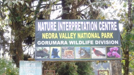
The Old Silk Route as the name suggests an ancient trading route which was once a transit point to the historic Silk Route from Tibet to India. The silk route that connected Lhasa (Tibet) to Kalimpong was in use even a few decades ago until the Chinese invasion of Tibet. It was commonly used by traders traveling to Tibet through Jelep-la (“La” stands for mountain pass) as an overnight base. The route started from Kalimpong and passed through Pedong, Aritar, Dzuluk and Jelepla to Chumbi valley in Tibet. During the past Silk Route was the connecting point between India and its neighboring countries to the east. But in the year 1962 after the Chinese aggression, Indian Government forced to close this route. For the last many years this region of Old Silk Route was remained under the strict supervision of Indian Army. During the past traveled by Old Silk Route merchants from China and Tibet visits India on Yak back and bring with them Silk and Cheese. On their return journey they took back flour, spices and fruits. As this route was travelled by foot hence it became Silk Route, there was another route traversed by water and it was known as Rice Route, this route was used for exchange of Rice, spices and grains. These routes have made well connectivity between India, Myanmar, China, Tibet and Iran. But these means of exchange was not confined within the exchange of raw materials but also Astrology, Mathematics, Religion and Chemistry were other means of exchange. In the past the main business focus of Silk Route was Nepal and of Rice Route was Bangladesh. But after the Chinese aggression Indian Government put a ban on this route a declared Nathula as the official corridor of exchange between India and Tibet. But recently Indian Government opened this route only for tourism purpose. Silk Route is home to many of the high altitude animals to name but a few are Himalayan Ghoral, Blue Sheep, Hawk, Deer, Monal and Crested Serpent Eagle. During the winter Indian Armies are trained here for high altitudes acclimatization. During the past Silk Route was the connecting point between India and its neighboring countries to the east. But in the year 1962 after the Chinese aggression, Indian Government forced to close this route. For the last many years this region of Old Silk Route was remained under the strict supervision of Indian Army. Permits are issued to tourists for visiting Lingtum to Yak Golf Course. The whole area is of 60 km. Tourists can extend their permit and travel further towards ‘New Baba Mandir’, Tsomgo and Gangtok from Rongli. In the year 1904 the British sent an expedition on this Old Silk Route under the leadership of ‘Connell Francis Young Husband’ who travelled this route of 500 km route to Tibet in 4 months. This track extending from ‘Yak Golf Course’ is also known as Young Husband Track’, which connected with Lahasa via ‘Chumbi Valley’.
Places of visit around Old Silk Route
Iccheygaon – Iccheygaon is a paradise for nature lovers, nestled at an altitude of about 5800 ft and covered with dense greenery of Pine, Oak, Fir and Birch trees all over. The word Iccheygaon literary means ‘The top most of the villages’. Iccheygaon is also known by the ‘Mungsong Forest Village’. Iccheygaon is inhabited mostly by Lepcha, Rai, Sherpa, Tamang and Bhujel. Nearby Iccheygaon there is a forest of ‘Sailikharka’.
Reaching There – The nearest railhead is NJP railway station which is about 87 km from Iccheygaon. Iccheygaon is located around 15 from Kalimpong and 15 km from Pedong.
Sillerygaon – Sillerygaon is a small village located in the Kalimpong hills of West Bengal and nestled at an altitude of about 6000 ft. Sillerygaon mainly comprises with simple village life, abundant species of flora and fauna along with wide varieties of flowers and stunning view of Mt. Kanchendzonga. Sillerygaon is located to the north – west side of Darjeeling. The name ‘Sillerygaon’ is derived from the huge ‘Cinchona’ plants that is produced here and has high medicinal values. Silleygaon is inhabited by around 30 to 40 families and their main source of livelihood is farming. The Villagers of Sillerygaon are very keen to upkeep the natural eco system of the village.
Reaching There – The nearest rail head is New Jalpaiguri and it is well connected both by train and bus route with major cities of India. Sillerygaon is about 90 km from New Jalpaiguri, 18 km from Kalimpong, 8 km from Pedong, 21 km from Rishikhola and 85 km from Siliguri. For those who avail the route from New Mal Junction, for them the route is Gorubathan and Lava.
Rishikhola – Rishikhola is a small village bordering between West Bengal and Sikkim. Nestled at an altitude of about 1800 ft. Rishikhola also acts as a gateway to Old Silk Route tour. Like all other rivulets crisscrossing the sub – Himalayan range, the Rishi River also known as Rishi Khola coasts is strewn with rocks and boulders with stream water gushing around them. The river valley is surrounded by forests which are home to numerous birds and occasional bigger visitors like bears.
Reaching There – The nearest railhead NJP railway station and is around 90 km from Rishikhola. Sillerygaon is around 18 km from Rishikhola.
Pedong – Pedong is bordering village between West Bengal and Sikkim. Pedong is amidst dense greenery of Pine, Oak, Birch and Deodar trees all over. Pedong is nestled at an altitude of about 5400 ft. ‘Cross Hill’ near Pedong is a natural galley for the 180 degree view of Mt. Kanchendzonga. Nearby Pedong small villages like Sakiang, Dalap, Kage, Upper Menchu, and Lower Menchu are worth visiting. Pedong is one of the main gateways to Old Silk Route tour.
Reaching There – The nearest railhead is NJP railway station. From Pedong around 15 km is Lava and 6 km is Algarah. Sillerygaon is within 9 km from Pedong.
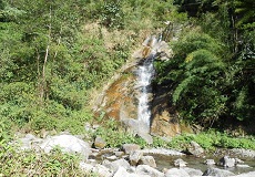
Rolep or Rolep Khola – Rolep is a small village of East Sikkim, lies on the banks of river Rolep Khola. Rolep nestled at an altitude of about 3500ft lays near Ronpo. Rolep is an ideal destination for nature lovers, bird watchers, landscape photographers and above all those who love to spend their vacation on the lap of nature with absolute silence all over. Rolep is tucked on the slopes of the rolling green Himalayan foothills with panoramic views of the Ranpo Khola River Valley. While is Rolep, you can hike along the hanging bridges over gushing rivers, get drenched under the 40 feet high waterfall and try angling Trouts in Rolep river. Rolep is one of the new found gems of East Sikkim which gives a very authentic experience of village life and adventure along. At Rolep tourists are welcomed in a traditional homestays and they are welcomed to be a part of the daily life of the local villagers and taste some sumptuous local cuisines.
Reaching There – The nearest railhead is New Jalpaiguri which is about 140 km and it takes about 04 to 05 hours. Rolep is around 12 km from Rongli.
Aritar – Aritar is a small village in east Sikkim located near a small pass of named Dalapchand. Aritar has a blend of nature and history in itself. Aritar is nestled at an altitude of about 5000 ft and the main attraction is ‘Aritar Lake’ locally named as ‘Lampokhri’ is 1120 ft long and 240 feet wide boot shaped lake is one of the oldest natural lakes in Sikkim. A pathway has been recently constructed all around the lake for the tourists. Tourists can enjoy paddle boating on Aritar Lake. Aritar is mainly Lepcha, Limboo, Newari, Rai, Gurung, Maggar, Sherpa, Tamang, Sanowar and Bhutias. From Aritar the nearby ‘Langchuk Valley’ is worth visiting which is on the way to ‘Lovedara’. Near Aritar there are two big villages Rongpo and Pakiyong. Nearby Aritar the local watchable includes Lampokhri, Aritar Dak Bungalow built by the then British political officer ‘James Clov White’ in the year 1896 at present this is the ‘Sikkim Treasury Office’.
Reaching There – The nearest rail head is NJP railway station, from here by shared or hired car upto Rongpo distance is about 75 km. From Rongpo via Rehnok, Aritar can be reached. From Gangtok via Rehnok at a distance of 116 km is Aritar. Other route is from Siliguri – Kalimpong – Pedong – Rishi – Rehnok – Aritar can also be reached.
Mankhim – Mankim also is a small village of East Sikkim and lies within 5km from Aritar on the way to uphill. It takes about 15 minutes from Aritar to reach Mankhim. Mankhim forms a natural gallery for sunrise at the backdrop of Mt. Kanchendzonga. Mankhim also offers aerial view Lampokhri or ‘Aritar Lake’ to the way downhill. Mankhim is nestled at an altitude of about 6500 ft. From Mankhim view point to the way more uphill tourists can visit Kirat Rai Temple.
Reaching There – Mankhim is located around 165 km from the nearest railhead NJP railway station. The route is from Kalimpong – Pedong – Rishi – Rehnok – Aritar by hired cars Mankhim can be reached.
Gadiigaon – Gaddigaon is about 10 minutes from Aritar by walking distance. Gaddigaon also offers panoramic view of Mt. Kanchendzonga along with ‘Lampokhri’ or ‘Aritar Lake’. GaddiGaon is a region in East Sikkim of India under Rongli Sub-Division, is known for its natural and landscaped beauty. It is located on the edge of the Himalayas. Gaddigaon (Aritar), a region in East Sikkim of India under Rongli Sub-Division, is known for its natural and landscaped beauty. It is located on the edge of the Himalayas.
Reaching There – Gaddigaon can be reached in about four and a half hours’ drive from the nearest railhead NJP railway station.
Rongpo Khola – Nestled at an altitude of about 3000 ft, the ‘Losing Machung” village lies on the banks of Rangpo River also locally known as ‘Rongpo Khola’. Rongpo Khola is home to one of the known fish of that region ‘Trout’. On and above Rongpo Khola there is a hanging bridge that offers panoramic view of the valleys along with the flowing water of Rongpo Khola. Near Rongpo Khola tourists can visit ‘Machung Monastery’. From Rongpo Khola around 05 km is Rongpo Dam, guarded by high raised mountains.
Rongli – Rongli is located on the banks of Rongli Khola and is mainly a market area. Rongli is a business hub of East Sikkim and nestled at an altitude of about 4000 ft. From Rongli SDPO office tourists are issued with entry permit to visit Silk Route and further extended to Tsomgo Lake and Gangtok.
Lingtum – Lingtum forms the main gateway to Old Silk Route, nestled at an altitude of about 4500 ft and is located within 10 km from Rongli. Lingtum is inhabited by around 50 families; the main livelihood of the locals is cultivation. The first check post on the Old Silk Route is at Lingtum. From Lingtum check post to a little further on the left hand side a route has connected to ‘Upasana Temple’ also known as ‘Old Lingtum Monastery’. And to a more further from the ‘Old Monastery’ nestled amidst dense greenness is ‘New Gompha’ or “New Lingtum Monastery’. Near Lingtum there is ‘Bakhutar Khola’ which is worth visiting. On the way from Lingtum to Padamchen tourist will come across Kui Khola waterfalls.
Reaching There – The nearest railhead is NJP railway station, from here the route is via Rongpo – Rongli around 121 km. From Lingtum around 23 km is Zuluk, ‘Adi Baba Mandir’ is about 53 km and Tsomgo is about 79 km.
Agamlok – Agamlok is an emerging new destination nestled at altitude of about 6000 ft just above Lingtum. Agamlok is comparatively a better option for staying other than Lingtum, as it is located on a bit higher altitude than Lingtum and tourists get it better to acclimatize for rest of the Silk Route tour. Moreover the scenic landscapes and the natural ambience of Agamlok is very eye catching. Agamlok is also known as Upper Lingtum. It takes around 20 to 25 minutes from Lingtum to reach Agamlok. At the top of Agamlok there is an age old Monastery which is worth visiting. Agamlok is abundant with many of the higher altitudes flowers, butterflies and Himalayan birds those inhabit the region. Agamlok is also known as Upper Lingtum.
Reaching There – Agamlok is located around 135 km from the nearest railhead NJP railway station and 40 km from Mankhim. Agamlok is located within 8 km from the entry of point of Old Silk Route Lingtum.
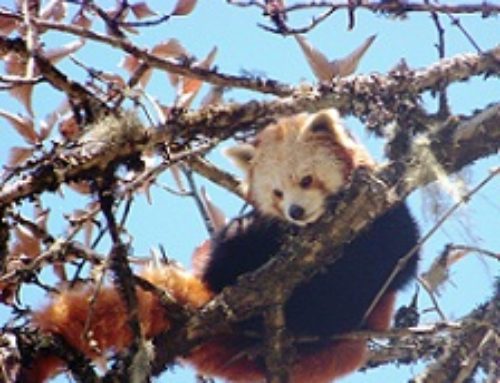
Padamchen – Padamchen nestled within the ‘Pangolakha Wildlife Sanctuary’ and is the home of the beautiful bird of Himalayas ‘The Himalayan Monal’. As Padamchen is a part of Pangolakha Wild Life division, therefore forest department charges 55/- each per pax as jungle entry fees and charges for cameras are extra and as applicable. Padamchen is a small village on the Old Silk Route located between Lingtum and Zuluk. Padamchen is nestled at an altitude of about 7500 ft. Padamchen is inhabited by Himalayan Black Bear, Leopard and Red Panda. Tourists visiting Padamchen need to collect the entry pass from ‘Nimachen’. From Padamchen tourists can visit ‘Rorathang Doban’. The word Doban is derived from a Nepali word which ‘confluence of two rivers’. At Doban River Rishi and River Rongli has intersected and flown towards Rongpo. Padamchen has some of the best views of the valleys and forests of this part of Sikkim at the Himalayan foothills. The forests around Padamchen support a wide variety of Himalayan bird population and bird watchers would love to spend a few days here.
Reaching There – The nearest railhead to Padamchen is NJP railway station, which is about 132 km. From NJP around 80 km is Rongpo, from there about 29 km is Rehnok, again from there about 16 km is Rongli and from Rongli via Lingtum about 14 km is Padamchen.
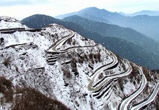
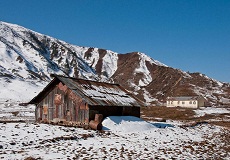
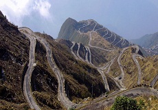
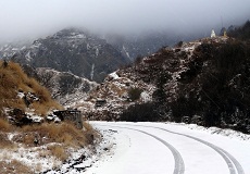
Zuluk – Zuluk or Dzuluk is nestled at an altitude of about 9400 ft. The word Zuluk comes from Tibetan word ‘Je- Lu’, that means pouring gun powder in guns. Zuluk is a hamlet close to the Indo – Tibet border relatively new and off beat tourist destination. Zuluk derives its importance for its location on the historic Old Silk Route. The route started from Kalimpong and passed through Pedong, Aritar, Zuluk and Jelep La to Chumbi Valley in Tibet. Situated on the rugged terrains of the lower Himalayas in east Sikkim, Zuluk or Dzuluk is a small village beside a winding road. It was once a transit point to the historic Silk Route from Tibet to India. It is relatively an emerging and off beat destination in east Sikkim. This small village of Zuluk accommodates a population of around 700 people. There is also an Indian Army transit base camp of ‘Cloud Warriors’ at Zuluk, which has been used as a transit camp for the army movement to the Chinese border, a few kilometers away. Zuluk is the very first village within this whole Silk Route circuit. During the winter Dzuluk gets covered with thick layers of snow. Around Zuluk tourists can visit Balasu Point, Salamidara View Point and temple of Lord Shiva.
Reaching There – The nearest railhead is New Jalpaiguri which is about 151 km and the nearest Airport is Bagdogra which is about 161 km. From Gangtok via Tsomgo and Tukla Valley around 85 km is Zuluk. From Zuluk it takes about 2.5 hours to reach Thambi View Point by trekking.
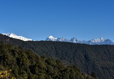
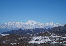
Lungthung – Lungthung is a small silent pass on located at east Sikkim Old Silk Route. Lungthung is about 01 hour journey from Zuluk. Located near Indo – Tibet border on the Old Silk Route, Lungthung is nestled at an altitude of about 12000 ft. Lungthung is inhabited by few Nepali families. During the past Lungthung was abundant in dense Dhupi jungles and hence it is also known as ‘Dhupi Dara’. The sunrise view from Lungthung in the early morning is a lifetime experience. At different seasons Lungthung depicts different views. During the winter Lungthung get covered with thick layers of snow. Lungthung is best visited during April – May and October – December. Tourists are advised to carry warm cloths as cold breeze blows at Lungthung throughout day and night. The word Lungthung means ‘Open Air’. While travelling to Lungthung View Point tourists will come across the 95 hairpin bends of Old Silk Route of Zuluk, though best viewed from Thambi. Lungthung offers a spectacular view of Mt. Kanchendzonga on one side and the enchanting beauty of the Zig Zag road that goes down to Zuluk through Thambi View Point on the other. In Lungthung the glittering golden yellow rays of the sun getting reflected from Mt. Kanchendzonga leaves a mesmerizing effect on travelers.
Reaching There – Lungthung is around 50 km from Rongli. Lungthung is a way uphill around 18 km from Zuluk.
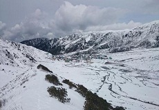
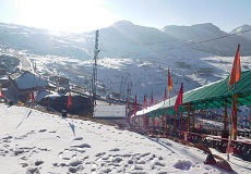
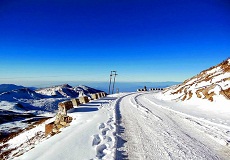
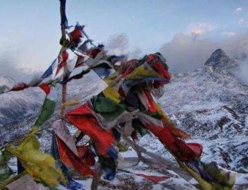
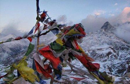
Gnathang Valley – If you do not like Gnathang Valley, then you would never like paradise. Located at an altitude of about 12700 ft, this lush valley was the home to traditional yak herders who came here from Tibet. Few streams crisscrossed the valley, and prayer flags flutter on the mountain edges on this vast plain of nothingness. Gnathang Valley appears in different colours in different seasons. From Gnathnag Valley to a little further is ‘Kalpohri’ a heart shaped lake. The locals also call it ‘Heart Lake’ or ‘Strawberry Lake’. But tourists are not allowed to get near the lake, as this area is under the surveillance of Indo- Tibetan border force. Gnathang Valley is an area of perennial snow. Gnathang Valley is being developed as Ski Point in Sikkim. Chinese watch towers on Jelep La are visible with naked eyes. Gnathang Valley remains covered with snow from November to April. The age old Monastery built in the year 1872 is a place of historic importance. From Gnathang Valley tourists can get around and visit Gnathnag Gaden Choling Monastery built in the year 1872, Gnathang War Memorial and Gnathang Dafter Bungalow built in the year 1920 by the British, though at present this the best homestay at Gnathang Valley.
Reaching There – From Zuluk via Lungthing, Thambi View Point and Lakshmi Chowk around 23 km is Gnathang Valley.
View Points at Old Silk Route
Damsang Fort – Damsang Fort was built by the Bhutanese in the year 1690 after they defeated the Lepcha Tribes. Though the Bhutanese could not keep it under their rule for long time. In the year 1864 Bhutan government handed over Damsang Fort to British, after they were defeated by the British government in Indo – Bhutan war. But during the earthquake of 2012 the fort was devastated.
Ramitey View Point – Ramitey View Point offers magnificent view of River Teesta along with Mt. Kanchendzonga. Ramitey View Point’ is about 3 km from Sillerygaon. Though Ramitey View point is also visited from both Iccheygaon and Pedong. Tourists can trek the route to Ramitey View Point from Sillerygaon, Iccheygaon and Pedong as well. The main attraction of Ramitey View Point is the view of 14 bends of River Teesta along at the bottom and with Mt. Kanchendzong standing tall.
Silent Valley – ‘Silent Valley’ near Sillerygaon is a ‘Lowland Meadow’. During monsoon near ‘Silent Valley’ a natural pond gets formed from the rain water and the locals call it ‘Siyal Pokhri’. ‘Silent Valley’ is an absolute. As the name suggests Silent Valley is a thriving green valley with absolute silence all over occasionally gets debarred by the chirping of Himalayan birds.
Sangchen Dorjee Monastery – Sangchen Dorjee Monastery is another sight of tourist’s interest that dates back to around 300 years old. Sangchen Dorjee Monastery is one of the oldest monasteries in Pedong-Kalimpong region and was built during the Bhutanese rule. This Monastery was established around the early 1700 AD. It provides historical insight into the history and culture of the place.
Thambi View Point – From Zuluk around 16 km is Thambi View Point. It takes about 2.5 hours from Zuluk to reach Thambi View Point by trekking. Thambi View Point offers panoramic view of the 95 hairpin bends of approaching from Zuluk on the Old Silk Route. Thambi View Point is nestled at an altitude of about 11200 ft. Thambi view point is about 25 km from Padamchen via Zuluk. These clusters of 95 hairpin bends of Zuluk are locally named as ‘Bhulbhulaiya’ or the ‘Zig Zag Road’.
Dhupidara, Salami View Point and Eagles Nest Bunker – Dhupidara is nestled at an altitude of about 11300 ft. Lungthung is located around 05 km uphill from Dhupidara. Dhupidara to the way further uphill is Salami View Point; this is a perfect spot for sunrise at the backdrop of Mt. Kanchendzonga. From Salami View Point to the way more further is ‘Eagles Nest Bunker’ of the Indo – Tibetan army. Eagles Nest Bunker offers stunning view of Mt. Kanchendzonga at the front, to the east are the ranges of Bhutan and at the far bottom flowing River Teesta. But tourists need to take permission to enter ‘Eagles Nest Bunker’.
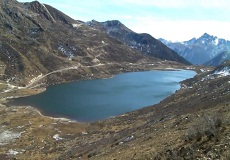
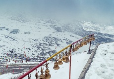
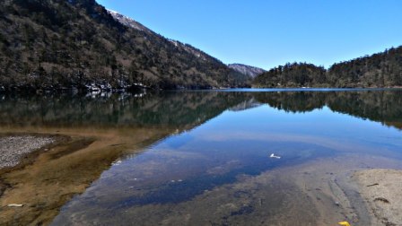
Kupup Valley and Kupup Lake (Elephant Lake) – ‘Kupup Lake’ or ‘Elephant Lake’ is nestled at an altitude of about 13900 ft. From ‘Kupup Lake’ as route has connected with ‘Jelep La’ pass. A route from Kupup Lake to the way further has connected with Lahasa via Jelep- La pass. On this route merchants used to trade wool, cheese, yak meat and silk. Kupup Lake is also known by the name ‘Bitan Sho’ to the locals. Kupup is a small village or valley comprises of small log huts with and an army barracks. Kupup remains covered with thick with snow 04 to 05 months of the year. There is something about high altitude lakes – you climb up the mountains, struggle through the hairpin bends and at the end you will greeted by a gleam of water body, a brilliant spectacle indeed. The Silk Route tour has several such high altitude lakes and one of the most beautiful is surely the Kupup Lake. It is one of the most sacred lakes of Sikkim, with high mountains and rugged valleys bordering it. ‘Kupup Lake’ also known as ‘Elephant Lake’ as the shape of this lake resembles to that of an elephant. From Kupup Lake to the way further is ‘Alpine Eco Park’. Kupup Lake has give birth to ‘River Jaldhaka’. From ‘Kupup Lake’ around 01 km further is ‘Kupup Village’.
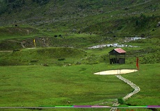
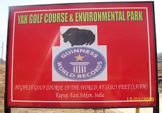
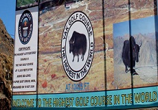
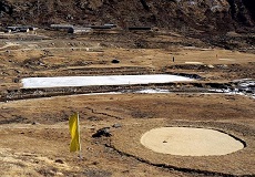
Yak Golf Course – From Kupup Lake to a little further lies ‘Yak Gold Course’ nestled at an altitude of about 14000 ft and this is the highest golf course in Asia. From ‘Yak Golf Course’ an ancient route has reached ‘Lahasa’ of Tibet distance is about 520 km. Though tourists are not allowed to travel further on this route due to border security reasons. ‘Yak Golf Course’ is located around 60 km from Lingtum Check post. Though started in the year 1972 ‘Yak Golf Course’ got its affiliation of ‘Indian Golf Union’ in the year 1985. Yak Golf Course has all total 18 holes spread on a wide area, golf players usually travel on Yak back to reach this Golf Course. At the end of ‘Yak Golf Course’ starts ‘Young Husband Track’, this track has connected with Lahasa via ‘Chumbi Valley’. In the year 1904 under the leadership of ‘Connell Francis Young Husband’ the British travelled this 500 km route to Tibet in 4 months.
Tukladara View Point and Tukla Valley – From ‘Old Baba Mandir’ to further uphill tourists will reach at ‘Tukla Valley’. From Lingtum check post about 53 km is ‘Tukla Valley’. Tukla Valley is nestled at an altitude of about 12500 ft. The route from ‘Laxmi Chowk’ and further towards ‘Gnathang Valley’ has met up at ‘Tukla Valley’. During winter and monsoon the region of Gnathang Valley and Tukla Valley get covered with snow. The true beauty of the Tibetan highlands can be experienced at Tukla Valley. Located at an altitude of around 12500 ft above sea level. Tukla Valley in Sikkim offers majestic and panoramic view of Mt. Kanchendzonga and its allied peaks. There is a war memorial named ‘Tukla War Memorial’ built in the memory of the British soldiers who fell at the battle of Tukla which was held between British and Tibetans in the year 1888.. The Tukla Valley remains covered with snow during the winters.
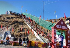
Adi Baba Mandir or Old Baba Mandir – ‘Adi Baba Mandir’ or ‘Old Baba Mandir’ is dedicated to ‘Baba Harbajan Singh’ an army officer from Punjab who was posted at Tukla Valley. But during the flood of 1968 he was on duty in this area and used to transfer food to the affected. But due to an accident he died on duty, and for in his memory the ‘Adi Baba Mandir’ or ‘Old Baba Mandir’ was built in this area. Tourists need to climb 70 staircases to reach ‘Adi Baba Mandir’.
Laxmi Chowk or Laxman Chowk – From Zuluk while travelling towards Gnathnag Valley tourists will come across Laxmi Chowk, which is about 2 km from Lungthung. From Laxmi Chowk a slight left turn will reach at Gnathnag Valley. Nest Bunker there is stone written ‘Laxmi Chowk’ kept in the memory of ‘Laxman Singh’. It is also known as ‘Laxman Chowk’.
Memencho Lake – It lies cradled between the mountains below the Jelep La Pass and is the source of river Rongpo – Chu. It derives its water from melting snow around. The lake is famous for its Trout and a farm to cultivate these fish also exists nearby. As it is a important trout breeding centre. Enthusiasts like to visit ‘Memencho Lake’ need to move further from ‘Yak Golf Course’ around 3.5 km. But separate permit is required to visit ‘Memencho Lake’ which is available from Gangtok. Memencho Lake is a beautiful Lake located 20 km ahead of Tsomgo Lake.
Permits – The permit for visiting Old Silk Route is available from Rongli SDPO office after validating the required documents. Though this permit is issued to Silk Route upto Tsomgo Lake via Gangtok. The permit to visit Nathula Pass is not issued from Rongli. Tourists need to present Voter’s Id card, Passport or Driving license to get the permit along with passport sized photographs. Tourists are advice to take more than one copies of their Identity proofs.
Getting There – The nearest railhead for Old Silk Route tour is New Jalpaiguri, which is well connected with other major cities of India. The nearest Airport is Bagdogra. From both NJP railway station and Bagdogra Airport tourists need to hire cars for the entire Silk Route trip. But please keep a note that cars of West Bengal are not permitted to enter Sikkim, therefore tourists are need to change car as they gets to enter Sikkim. The inner line permits for visiting Old Silk Route are provided from Rongli SDPO office.
Important things to know – Tourists with breathing problem or heart related problems should staing at Gnathnag Valley and instead they can opt for their stay either at Padamchen or at Zuluk. In this route availability of clinics or hospital are not available except the Army health centre. It is advised to carry required medicine. Mobile networks are very poor in this region. Tourists are also advised to carry enough warm and woolen cloths. In this region Rongli is the last market, from here the locals buy their regular useful products, medicine, food and raw materials.
Best time to visit – Silk Route can be visited throughout the year except monsoon. October – December is the best time. January – March is the best time to view the snow in this region.
Distance and Altitudes
Siliguri – Sillerygaon: 96 km: 6000 ft.
Sillerygaon – Aritar: 19 km: 5000 ft
Aritar – Zuluk: 42 km: 9400 ft
Zuluk – Lungthung: 18 km: 12000 ft
Lungthung – Laxmi Chowk: 2 km: 12500 ft
Laxmi Chowk – Adi Baba Mandir: 3 km: 13000 ft
Adi Baba Mandir – Gnathang Valley: 9 km: 12700 ft
Gnathang Valley – Kupup Lake: 10 km: 13900 ft
Kupup – Gangtok: 44 km: 13900 ft
Lingtum – Aritar: 10 km: 4000 ft
Bird’s Species commonly spotted around Old Silk Route
Verditer Flycatcher
Green Backed Tit
Leaf Bird
Himalayan Bulbul
Streaked Spider catcher
Scarlet Minivet
Laughing Thrush
Fullvetta
Honey Buzzard
Steppe Eagle
Babblers
Tit
Plumbius Water Redstart
White Capped Water Redstart
Himalayan Monal
Blood Pheasant
Khaliz Pheasant
Snow Pheasant
Rusty Sparrow
Fire Tailed Sunbird
Olive Backed Pipit
Blue Fronted Redstart
Wrens
Distance of Rorathang from other destinations
Aritar – 20 km
Pedong – 35 km
Sillerygaon – 42 km
Zuluk – 50 km
Gangtok – 55 km
Kalimpong – 65 km
Siliguri – 95 km
Traditional local cuisines available around Old Silk Route
Ruk Ruk – This is a traditional Tibetan food that tastes a bit sweet and salty.
Khabji – A traditional Tibetan sweet dish.
Phale – This is a form of Tibetan chapatti, it is prepared with wheat flour, tomatoes, onion, chili and other spices. On addition of meat with this chapatti, it named as Sa – Phale and on addition of egg it becomes Khulip – Phale.
Tingmo – This is a local momo of that region prepared with wheat flour, carrots and Rai leaf.
Yak – Sa – This is the dry form of Yak meat. Tourists often gets to see dry Yak meats hanging from the roof of most of the houses. In this high altitude regions these dry meat remains preserved and fresh for longer times.
For any queries on Old Silk Route, please call us at 9831311606 , 9831163113


Leave A Comment
You must be logged in to post a comment.